Ngorongoro Conservation Area
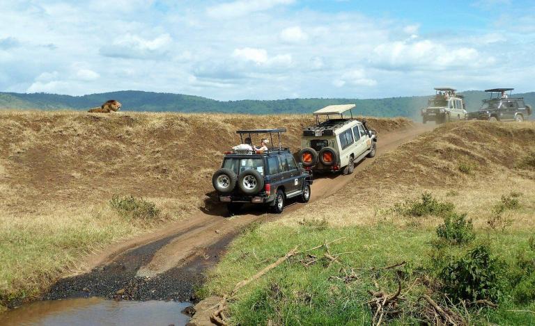
Ngorongoro Conservation Area is the name given to the 8,300 square kilometre piece of land that surrounds the famous Crater and the Highlands of the same name. The Crater was once the headquarters of Serengeti National park of which it was an integral part, but in 1956, after intense pressure and lobbying from the local Masai community who were dispossessed of the lands when the National Park was set up, Ngorongoro was designated a Conservation Area. The 210 square km Crater is now one of the principal attractions on the Northern Tanzanian Safari Circuit and the reputation of the Crater Highlands is slowly developing as a premier trekking destination. The Crater is all that it is made out to be, the hyperbole about the Garden Of Eden, the Eighth Wonder Of The World etc all justified by its perennial animal population. This cross-section of wildlife is about as convenient as you will find, dispersed amongst an amazing array of ecosystems within the Natural Amphitheatre created by 600-metre-high cliffs around it. It is home to one of the few remaining populations of black rhinos in Tanzania and just about every other East African mammal, with the exception of giraffe (walls are too steep) and impala, all unafraid and used to the constant retinue of vehicles. The crater has the highest density of lions in Africa, with over 30 lions per 100 sq kms, compared to the Serengeti which has about 14 lions per 100sq kms and Kruger National Park in South Africa with about 10 lions per 100 sq kms. In Ngorongoro, it is not uncommon to find lions lying in the shade of parked tourist vehicles! The Ngorongoro Conservation Area is unique in that the area is shared between the pastoralist Masai tribe and the wildlife the area was established to preserve.
- Ngorongoro Conservation Area
- Walking Safaris
- Oldoinyo Gol and Eastern Plains
- Ndutu Woodlands
- Endolun Village and Eyasi Escarpment
- Highlands and Oldoinyo Lengai
Main Mammals
- Wildebeest - Zebra - Buffalo - Elephant - Black Rhinoceros - Lion - Thomson Gazelle - Grants Gazelle - Leopard - Hyena - Hippopotamus - Cheetah

Seasons
Green and lush, a popular place to visit, although after rains most of the crater roads can be impassable.
This is the dry season and the crater can be very dusty and warm in the afternoon. Very popular and not unusual to see over 300 vehicles, especially in the mornings.
Walking in the Ngorongoro Highlands provides opportunities for visitors to experience the majesty of the Conservation Area without having to sit in a vehicle for 12 hours a day. On most of these walking safaris wildlife will be seen but usually at a distance, and it is highly likely that the camp will be visited by game at night. The scenery is spectacular and is the main attraction to the area, plus the possibility of interaction with the local Masai. On all our walks we have vehicular support and two-way VHF radios.
Best during the wet season from December through to May when there are usually large numbers of plain animals. Immense open landscapes and huge skies. Campsites here are few and far apart and will need to book far in advance. From Olduvai Gorge to Nasera Rock is 31 kilometres and rising 400 metres in elevation, taking about 14 hours. From Nasera Rock to Olkarien Gorge, the largest breeding ground for Griffin Vultures is about 15 hours and 35 kilometres through the foot-hills of the Gol Mountains.
Also best during the wet season from December through to May when the wildebeest gather for the calving seasons. Most of the walks on offer in this area are usually less than a day with one of the NCAA guides from the camps or lodge in the area. Really worthwhile as walks are often taking along the shores of Lake Ndutu.
Located to the southeast, the area consists of open grasslands with forested gorges. Mt Lemagrut is one of the main features in the area, from the summit of which are views of the Serengeti Plains, Lake Eyasi and the Ngorongoro Crater. Day walks from the camp at the village of Endolun to the Eyasi escarpment where we find fine rock formations, baobab trees and great views over Lake Eyasi. Lake Eyasi is Tanzania’s largest soda lake, surrounded by palm and acacia woods. Many diverse cultures live around the lake, including the Hadzabe hunter gatherers and Datoga pastoralist.
This is probably the best-known area for walking safaris in the Ngorongoro Highland. Located to the northwest of the crater and heading towards the spectacular Lake Natron area which includes the active volcano Oldoinyo Lengai, known by the Masai as “the Mountain of God.” The area consists of open grasslands, spectacular natural features such as Empakai crater and Mt Lolmalasin, the third highest mountain in Tanzania. Many Masai villages are located in the highlands and cultural interaction is always a possibility. This is probably the best area for walking expeditions of between two to six days, starting near the crater at Olmoti Crater and walking towards Oldoinyo Lengai, trekking down the Rift escarpment and eventually ending up at Lake Natron. Between Empakai and Oldoinyo Lengai there is no vehicle access down the escarpment, so no vehicular support is possible for one to two days. All the campsites are special campsites with no facilities whatsoever which are all carried in by support vehicles.

